Four of us (myself, Jen, John and Miriam) hiked up Chalk Mountain in Big Basin State Park on Saturday, 7/31/2010. Most people in the Bay Area are familiar with this park, or have at least heard of it. If you have, you've probably been to the main entrance, maybe to Berry Creek Falls via the Skyline-to-the-Sea trail, either from the main entrance or Waddell Beach on Highway 1. Chalk Mountain from Waddell Beach, probably not, as evidenced by the fact that we saw nobody else from turning off Skyline-to-the-Sea until we rejoined the "waterfalls trail" on the way out, and saw the usual Saturday Berry Creek Falls traffic. Somewhat surprising - I expected to see a couple mountain bikers on Chalks Road, anyway.
Jen took a few pictures, but I don't have them yet. Instead, I'll give you a link to another group's trip, and you can look at THEIR pictures, which they took a whole lot of: San Jose Hiking Club Meetup
And no, we didn't get the idea from them. There is a certain amount of suspicion that they got the pointer to "Chalk Mountain" from US. You see, I've been thinking about this for some time, mentioned it to John and Miriam, who organize weekly hikes (and incredibly well). John talked it up to a lot of people, including some active in THAT group, so ... well, probably not. At any rate, when I first noticed it on the Big Basin map and wondered about it, I couldn't dig up that many first hand accounts, and most of what I found were mountain biker's trip reports, though they did tip me off that there was that unmapped trail from the top of Henry Creek trail over to Golden Cascade. Nice of SJHC to do a scouting report for us ... We elected to go around the opposite direction from them (makes more sense to do the big climb early, if everyone's willing to commit to the whole thing to get to the falls).
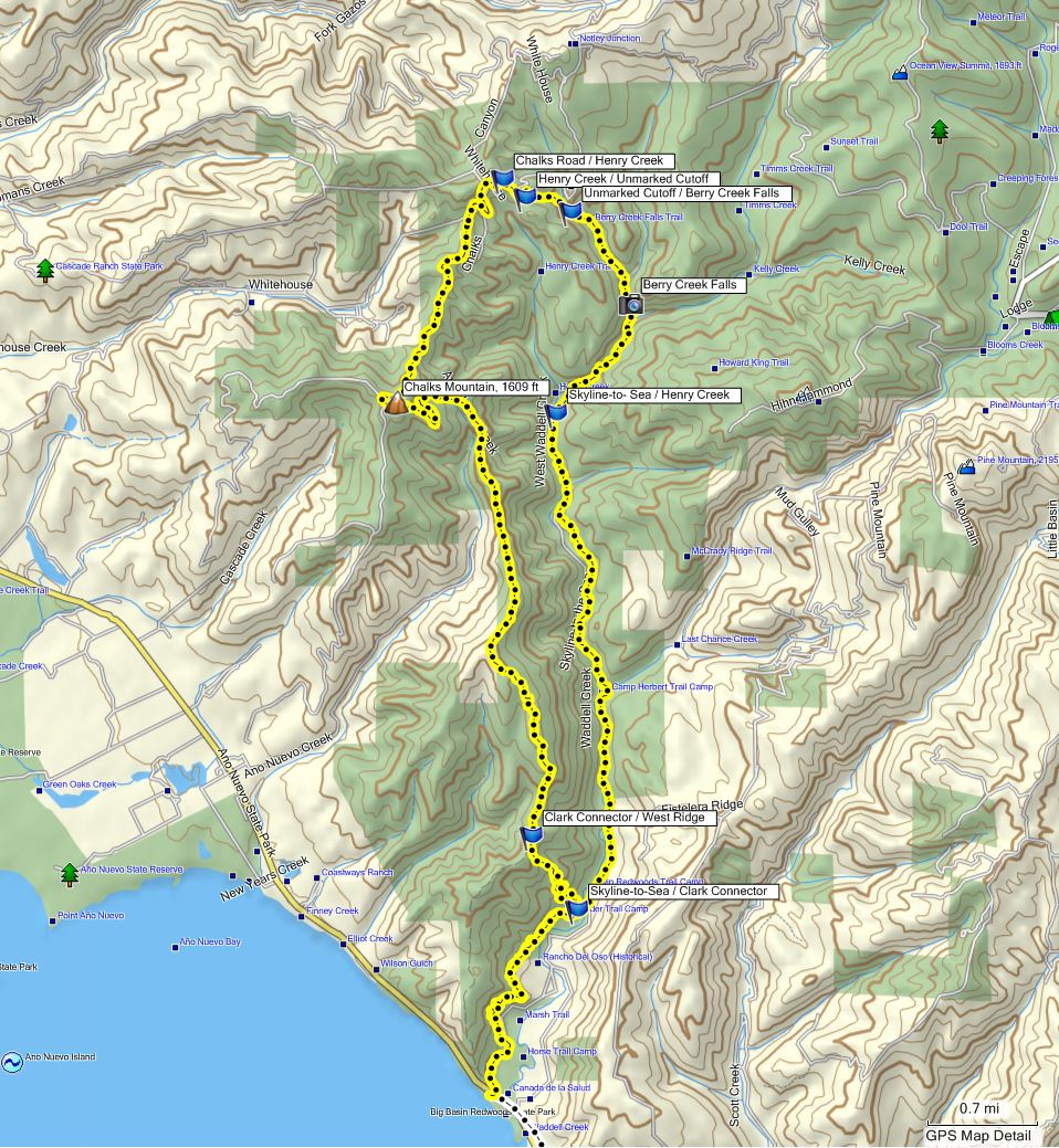
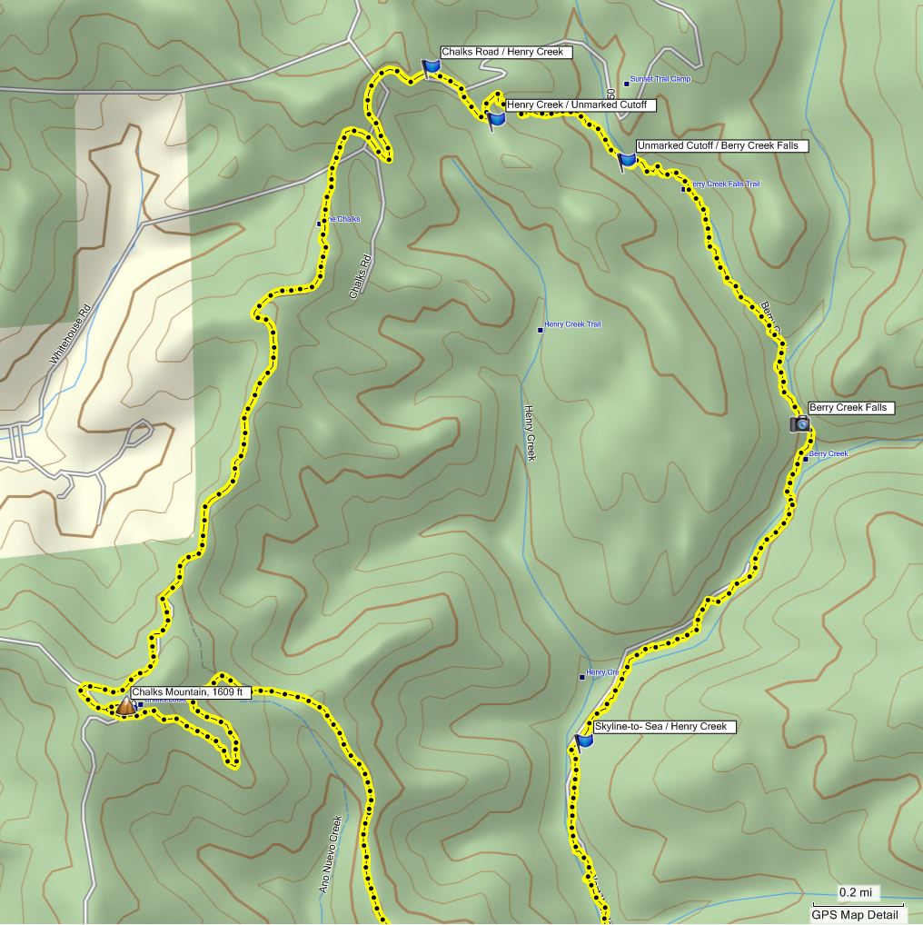
Anyway, I DID get GPS data. Here's a couple maps of the route we took:
The blue flags are trail junctions, so the labels on them refer to the trails by those names, not actual features.
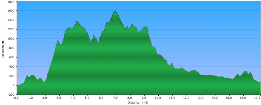
The elevation profile tells the story:
Yeah, the high point was 1600 feet starting at sea level, but with loss and regain, I estimate 3400 - 3800 worth of total climb, and some of those grades are as steep as they look. For those of you familiar with the well-traveled Skyline-to-the-Sea trail to Berry Creek Falls and the falls above it, we departed from SttS at mile 2 to go up the Clark Connector. We rejoined the Berry Creek Falls trail just above Golden Cascade at the 800 foot mark a little before mile 10. Berry Creek Falls itself is at 460 feet, around mile 11. At least it was relatively cool. That probably contributed to our repectable stats:
Distance - 17.2 miles (edited to remove false data while stopped)
Elapsed time - 7:48, for 2.2 mph
Moving time - 6:23, for 2.7 mph (removing 85 minutes for lunch break, gawking at falls, viewpoints, gazing in horror at slopes, etc)
Nice hike, though. From the tree covered Skyline-to-the-Sea, you switchback steeply up the Clark Connector to break out onto the West Ridge trail and follow said ridge around the gully containing Ano Nuevo Creek to reach the mountain. You change from redwood / tanoak forest to the rocky pine scrub / manzanita landscape which leads to the area being called "The Chalks".
The mountain is a broad, flat-topped affair with a small radio tower and, oddly, an outhouse. Good views out to the ocean, and back into Big Basin, from the outhouse. From the mountain, you find yourself on "Chalks Road". Yeah, fire road. This area is a favorite of the mountain bikers, many of whom come up from Whitehouse road, by far the easier way to get to Chalk Mountain. Anyway, we traveled along that to find the turnoff for Henry Creek trail.
We were keeping a sharp lookout for the "secret" trail over to the Berry Creek falls trail - Henry Creek trail comes out below Berry Creek falls, and would require a significant backtrack to get to the falls. Heh. It wasn't terribly hard to find, and was quite a nice trail, a shaded single track descending again into forest to come out just above Golden Cascade. For reference, the "secret" trail is at:
37 10 45 N, 122 16 36 W - Henry Creek end.
37 10 40 N, 122 16 16 W - Berry Creek end.
One DOES wonder why Big Basin doesn't make that route official.
Anyway, at that point we rejoined the hordes (well, the dozens, anyway), descended past the falls, and took the Skyline-to-the-Sea back out to the car.